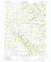
1961 Map of Jersey
USGS Topo · Published 1975About this map
Pataskala and the surrounding agricultural townships of Licking County are captured here in a period of transition as suburban expansion begins to meet established rural crossroads. Located within the historic United States Military District, the landscape is defined by a dense network of family-named intersections such as Millers Corners, Tylers Corners, and Parkhurst Corners. The South Fork Licking River flows through the southern portion of the map near Columbia Center, while the Penn Central railroad corridor provides a heavy industrial artery through the terrain. Genealogists will find a wealth of local landmarks, from the Universalist Ch and Harmony Ch to several small family and parish burial grounds, including St Joseph Cem, Burnside Cem, and Wickliff Cem. The map also records early 1970s infrastructure, including multiple Radio Towers and a prominent pipeline cutting across Jersey township.
Find a feature on this map
42 named features on this map. Tap any name to fly to it.
Don’t see what you’re looking for? This feature index may not catch every label — zoom into the map to look around manually.
Map Details
Editions of this 1961 Jersey Map
Other maps of this area

1902 · Westerville
USGS Topo · 1:62,500

1904 · Westerville
USGS Topo · 1:62,500

1907 · Thurston
USGS Topo · 1:62,500

1908 · Granville
USGS Topo · 1:62,500

1909 · Thurston
USGS Topo · 1:62,500

1910 · Granville
USGS Topo · 1:62,500

1925 · East Columbus
USGS Topo · 1:62,500

1943 · East Columbus
USGS Topo · 1:62,500

1947 · Columbus
USGS Topo · 1:250,000

1950 · Marion
USGS Topo · 1:250,000