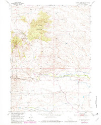
1953 Map of Johnson Mountain
USGS Topo · Published 1982About this map
Butner Ranch and several other family-owned operations anchor this mid-century survey of Platte County, where the Laramie River system dictates the settlement pattern. The landscape is dominated by the high ground of Johnson Mountain and Sheep Mountain, while the valley floors are utilized for agriculture and water management, evidenced by the Mitchell Canal and the Pipe Line running through the southern reaches. Local education and community life are marked by the Sommers-Shockley School and a Boy Scout Camp near the river.
Find a feature on this map
28 named features on this map. Tap any name to fly to it.
Don’t see what you’re looking for? This feature index may not catch every label — zoom into the map to look around manually.
Map Details
Editions of this 1953 Johnson Mountain Map
4 editions found
Other maps of this area

1943 · Esterbrook
USGS Topo · 1:62,500

1945 · Esterbrook
USGS Topo · 1:62,500

1950 · Coleman Butte
USGS Topo · 1:24,000

1950 · Cottonwood Falls
USGS Topo · 1:24,000

1951 · Coleman Butte
USGS Topo · 1:24,000

1951 · Cottonwood Falls
USGS Topo · 1:24,000

1953 · Lewis Flat
USGS Topo · 1:24,000

1953 · Hightower
USGS Topo · 1:24,000

1953 · Hightower SW
USGS Topo · 1:24,000

1953 · Johnson Mountain
USGS Topo · 1:24,000