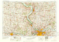
1960 Map of Kansas City
USGS Topo · Published 1960About this map
The Missouri River corridor serves as the primary artery for this mid-century survey, anchoring major regional hubs from Saint Joseph down to the sprawling metropolitan complex of Kansas City and Independence. The landscape is a study in 1950s infrastructure and land use, featuring the nascent Kansas Turnpike and a dense network of major railroads like the Union Pacific and Atchison Topeka and Santa Fe.
Find a feature on this map
47 named features on this map. Tap any name to fly to it.
Don’t see what you’re looking for? This feature index may not catch every label — zoom into the map to look around manually.
Map Details
Editions of this 1960 Kansas City Map
3 editions found

Other maps of this area

1885 · Eskridge
USGS Topo · 1:125,000

1885 · Warrensburg
USGS Topo · 1:125,000

1885 · Atchison
USGS Topo · 1:125,000

1885 · Lawrence
USGS Topo · 1:125,000

1886 · Oskaloosa
USGS Topo · 1:125,000

1887 · Harrisonville
USGS Topo · 1:125,000

1887 · Olathe
USGS Topo · 1:125,000

1887 · Warrensburg
USGS Topo · 1:125,000

1888 · Oskaloosa
USGS Topo · 1:125,000

1888 · Atchison
USGS Topo · 1:125,000