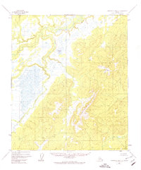
1952 Map of Kantishna River C-5
USGS Topo · Published 1974About this map
The Chitanana River defines the western reaches of this subarctic landscape, winding through a complex network of wetlands and oxbow lakes as it flows toward the Tanana River basin. Based on 1952 aerial photography, the terrain is dominated by the sprawling Chitanana Hills in the southeast, where elevations rise sharply above the saturated lowlands. A prominent landmark within this wilderness is Redlands Lake, which sits tucked into a transition zone between the river flats and the rising foothills. The map reveals an untouched interior during the mid-twentieth century, showing no roads, trails, or permanent settlements, preserving a record of the hydrological patterns and topographic relief of this part of the Yukon-Koyukuk region before any modern industrial or recreational encroachment occurred.
Find a feature on this map
3 named features on this map. Tap any name to fly to it.
Don’t see what you’re looking for? This feature index may not catch every label — zoom into the map to look around manually.
Map Details
Editions of this 1952 Kantishna River C-5 Map
4 editions found
Other maps of this area

1948 · Kantishna River
USGS Topo · 1:250,000

1951 · Kantishna River
USGS Topo · 1:250,000

1952 · Kantishna River C-5
USGS Topo · 1:63,360

1952 · Kantishna River C-6
USGS Topo · 1:63,360

1952 · Kantishna River D-5
USGS Topo · 1:63,360

1952 · Kantishna River
USGS Topo · 1:250,000

1952 · Kantishna River B-6
USGS Topo · 1:63,360

1952 · Kantishna River D-6
USGS Topo · 1:63,360

1952 · Kantishna River B-5
USGS Topo · 1:63,360

1952 · Kantishna River C-4
USGS Topo · 1:63,360