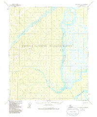
1952 Map of Kateel River A-4
USGS Topo · Published 1986About this map
Koyukuk National Wildlife Refuge encompasses the vast majority of this landscape, where the meandering Gisasa River flows from the west to meet the larger Koyukuk River. This 1952 photogrammetric survey reveals a wilderness defined by water and low-lying wetlands, documented well before the federal reservation boundaries were officially established in 1980. The intricate network of side channels is marked by features like Koyukuk Slough and Chips Slough, which separate Chips Island from the mainland.
Find a feature on this map
13 named features on this map. Tap any name to fly to it.
Don’t see what you’re looking for? This feature index may not catch every label — zoom into the map to look around manually.
Map Details
Editions of this 1952 Kateel River A-4 Map
5 editions found
Other maps of this area

1945 · Nulato
USGS Topo · 1:250,000

1951 · Nulato
USGS Topo · 1:250,000

1951 · Kateel River
USGS Topo · 1:250,000

1952 · Nulato D-3
USGS Topo · 1:63,360

1952 · Nulato D-5
USGS Topo · 1:63,360

1952 · Kateel River A-4
USGS Topo · 1:63,360

1952 · Nulato D-4
USGS Topo · 1:63,360

1952 · Kateel River A-3
USGS Topo · 1:63,360

1952 · Kateel River B-3
USGS Topo · 1:63,360

1952 · Nulato
USGS Topo · 1:250,000