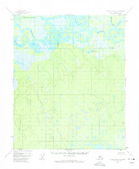
1952 Map of Kateel River B-3
USGS Topo · Published 1974About this map
The Koyukuk River dominates this mid-century Alaskan landscape, its winding course forming complex oxbows and meanders through the northern interior. This 1952 aerial study captures a wilderness defined by its waterways, including the broad Three Day Slough and the Bitzla River flowing from the south. The terrain is characterized by extensive wetlands and lakes such as Tachanlowa Lake, Sam White Lake, and Nogadanvoda Lake. Signs of human presence are minimal but documented through a few isolated structures, including Cabins and a lone Cabin situated along the riverbanks. Geographic landmarks like Sand Bluff and the VABM Pivot provide fixed reference points in a region of low relief where the natural drainage patterns shift seasonally across the flats. This survey represents a specific moment in the mapping of the Alaska interior before more modern infrastructure ever reached this remote river system.
Find a feature on this map
12 named features on this map. Tap any name to fly to it.
Don’t see what you’re looking for? This feature index may not catch every label — zoom into the map to look around manually.
Map Details
Editions of this 1952 Kateel River B-3 Map
3 editions found
Other maps of this area

1951 · Kateel River
USGS Topo · 1:250,000

1952 · Kateel River A-2
USGS Topo · 1:63,360

1952 · Kateel River A-4
USGS Topo · 1:63,360

1952 · Kateel River A-3
USGS Topo · 1:63,360

1952 · Kateel River B-3
USGS Topo · 1:63,360

1952 · Kateel River B-2
USGS Topo · 1:63,360

1952 · Kateel River B-4
USGS Topo · 1:63,360

1954 · Kateel River C-4
USGS Topo · 1:63,360

1954 · Kateel River C-2
USGS Topo · 1:63,360

1954 · Kateel River C-3
USGS Topo · 1:63,360