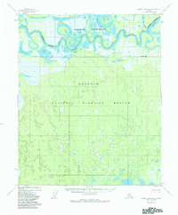
1952 Map of Kateel River B-3
USGS Topo · Published 1984About this map
The Koyukuk River winds through a vast alluvial landscape in this mid-century survey, revealing a complex network of oxbow lakes and wetlands. The river's serpentine path is punctuated by features like Sand Bluff, while the surrounding terrain is dominated by significant water bodies such as Tachantowa Lake and Nogadanooda Lake. This region, documented just after the era of early Arctic aviation and traditional river travel, shows a wilderness largely devoid of roads or permanent settlements, save for isolated Cabins near the northern boundary.
Find a feature on this map
13 named features on this map. Tap any name to fly to it.
Don’t see what you’re looking for? This feature index may not catch every label — zoom into the map to look around manually.
Map Details
Editions of this 1952 Kateel River B-3 Map
3 editions found
Other maps of this area

1951 · Kateel River
USGS Topo · 1:250,000

1952 · Kateel River A-2
USGS Topo · 1:63,360

1952 · Kateel River A-4
USGS Topo · 1:63,360

1952 · Kateel River A-3
USGS Topo · 1:63,360

1952 · Kateel River B-3
USGS Topo · 1:63,360

1952 · Kateel River B-2
USGS Topo · 1:63,360

1952 · Kateel River B-4
USGS Topo · 1:63,360

1954 · Kateel River C-4
USGS Topo · 1:63,360

1954 · Kateel River C-2
USGS Topo · 1:63,360

1954 · Kateel River C-3
USGS Topo · 1:63,360