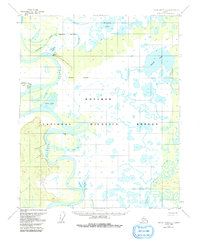
1954 Map of Kateel River C-1
USGS Topo · Published 1991About this map
Huslia serves as the primary hub of activity along the meandering bends of the Koyukuk River in this mid-century Alskan interior landscape. The topography is defined by an intricate network of waterways and wetlands, much of which is encompassed by the Koyukuk National Wildlife Refuge. Transportation in this remote environment is heavily reliant on the water and seasonal routes, evidenced by the Landing Strip near the settlement and the Winter Trail leading to Richards Camp. The interior is a mosaic of massive lakes and serpentine channels, including Willow Lake and Racetrack Slough, which dominate the eastern and northern portions of the quadrangle. Small outposts like Simon Cabin and various seasonal camps suggest a landscape utilized for traditional subsistence and wildlife management during the early 1950s.
Find a feature on this map
18 named features on this map. Tap any name to fly to it.
Don’t see what you’re looking for? This feature index may not catch every label — zoom into the map to look around manually.
Map Details
Editions of this 1954 Kateel River C-1 Map
3 editions found
Other maps of this area

1951 · Kateel River
USGS Topo · 1:250,000

1951 · Melozitna
USGS Topo · 1:250,000

1952 · Kateel River B-1
USGS Topo · 1:63,360

1952 · Kateel River B-2
USGS Topo · 1:63,360

1954 · Kateel River C-2
USGS Topo · 1:63,360

1954 · Melozitna C-6
USGS Topo · 1:63,360

1954 · Kateel River C-1
USGS Topo · 1:63,360

1954 · Kateel River D-1
USGS Topo · 1:63,360

1954 · Melozitna D-6
USGS Topo · 1:63,360
1954 · Melozitna B-6
USGS Topo · 1:63,360