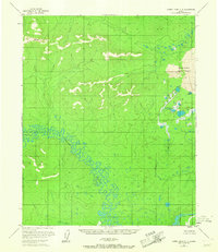
1954 Map of Kateel River C-4
USGS Topo · Published 1967About this map
Kateel River meanders across this subarctic landscape in complex oxbows and loops, defining a region where water and sediment constantly reshape the terrain. Photogrammetric methods from 1952 and 1954 aerial surveys reveal a wilderness marked by distinctive geological formations, most notably the Nogahabara Sand Dunes in the northeast and a singular Pingo rising from the wetlands. Small signs of human presence are sparse, indicated only by a Cabin and the name Pithka along the riverbanks. The drainage system is further defined by the Hodatic River and the Three Day Slough, where land lines remain unsurveyed and predetermined by the Bureau of Land Management. This mid-century record provides a glimpse into the hydrography of the interior before later ecological or climatic shifts altered these remote waterways.
Find a feature on this map
7 named features on this map. Tap any name to fly to it.
Don’t see what you’re looking for? This feature index may not catch every label — zoom into the map to look around manually.
Map Details
Editions of this 1954 Kateel River C-4 Map
3 editions found
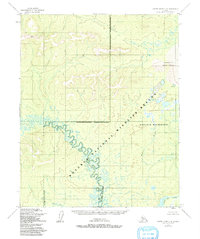
Other maps of this area

1951 · Kateel River
USGS Topo · 1:250,000

1952 · Kateel River B-3
USGS Topo · 1:63,360

1952 · Kateel River B-4
USGS Topo · 1:63,360

1954 · Kateel River C-4
USGS Topo · 1:63,360

1954 · Kateel River C-3
USGS Topo · 1:63,360

1954 · Kateel River D-3
USGS Topo · 1:63,360

1954 · Kateel River D-4
USGS Topo · 1:63,360

1954 · Kateel River B-5
USGS Topo · 1:63,360

1954 · Kateel River D-5
USGS Topo · 1:63,360

1955 · Kateel River B-5
USGS Topo · 1:63,360