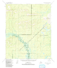
1954 Map of Kateel River C-4
USGS Topo · Published 1992About this map
Koyukuk River meanders dramatically across this subarctic landscape, carving deep oxbows and intricate loops through the central portion of the survey area. In the early 1950s, this region was characterized by its immense hydrological complexity, where the main channel meets the Hodatic River and feeds into the extensive Three Day Slough system. The terrain is marked by a notable contrast between the riparian lowlands and the Nogahabara Sand Dunes in the northeast, a rare aeolian feature in this environment. The settlement of Pitka stands as a solitary human marker in a territory largely defined by the Koyukuk National Wildlife Refuge and the Koyukuk Wilderness. The map captures the undisturbed natural state of these watersheds before later administrative boundary designations were formally finalized, providing a clear record of the original stream paths and shoreline topography.
Find a feature on this map
10 named features on this map. Tap any name to fly to it.
Don’t see what you’re looking for? This feature index may not catch every label — zoom into the map to look around manually.
Map Details
Editions of this 1954 Kateel River C-4 Map
3 editions found
Other maps of this area

1951 · Kateel River
USGS Topo · 1:250,000

1952 · Kateel River B-3
USGS Topo · 1:63,360

1952 · Kateel River B-4
USGS Topo · 1:63,360

1954 · Kateel River C-4
USGS Topo · 1:63,360

1954 · Kateel River C-3
USGS Topo · 1:63,360

1954 · Kateel River D-3
USGS Topo · 1:63,360

1954 · Kateel River D-4
USGS Topo · 1:63,360

1954 · Kateel River B-5
USGS Topo · 1:63,360

1954 · Kateel River D-5
USGS Topo · 1:63,360

1955 · Kateel River B-5
USGS Topo · 1:63,360