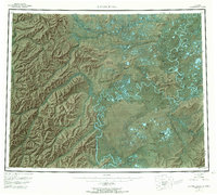
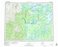
1955 Map of Kateel River
USGS Topo · Published 1969About this map
The Kateel River and Koyukuk River dominate this mid-century interior landscape, where the shifting hydrology of the arctic floodplains is visible through a complex network of sloughs and cutoffs. The map records a series of essential riverfront sites and camps that supported travel and subsistence, including Huslia Landing Area and the Old Cutoff Trading Post, listed here as abandoned. Further inland, the distinctive Nogahabara Sand Dunes contrast with the surrounding marshy lowlands and the higher elevations of Roundabout Mountain. Small-scale structures like Tobys Cabin and Chips Cabin mark individual footprints in the wilderness, while named locations such as Colville Bend and Over The Hill Portage suggest established routes used before more modern infrastructure reached the region. The map also delineates the Continental Divide as it winds through the western ridges, separating the major drainage basins of the Yukon-Koyukuk area.
Find a feature on this map
82 named features on this map. Tap any name to fly to it.
Don’t see what you’re looking for? This feature index may not catch every label — zoom into the map to look around manually.
Map Details
Editions of this 1955 Kateel River Map
6 editions found

Other maps of this area

1945 · Nulato
USGS Topo · 1:250,000

1948 · Norton Bay
USGS Topo · 1:250,000

1951 · Candle
USGS Topo · 1:250,000

1951 · Selawik
USGS Topo · 1:250,000

1951 · Shungnak
USGS Topo · 1:250,000

1951 · Nulato
USGS Topo · 1:250,000

1951 · Ruby
USGS Topo · 1:250,000

1951 · Norton Bay
USGS Topo · 1:250,000

1951 · Kateel River
USGS Topo · 1:250,000

1951 · Hughes
USGS Topo · 1:250,000