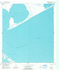
1951 Map of Keller Bay
USGS Topo · Published 1992About this map
Keller Bay and the surrounding coastal waters of Matagorda Bay dominate this mid-century survey of the Texas Gulf Coast. The map reveals a maritime landscape defined by its shifting shorelines and navigational hazards, most notably the multiple instances of a Sunken Wreck resting in the shallow waters off Indianola Island. This area, situated between Lavaca Bay and Redfish Lake, reflects a period when coastal activity was marked by a few isolated landmarks such as a Windmill and scattered Derrick structures. The intricate marshlands and inlets near Indianola Bayou and Powderhorn Lake provide a detailed look at the geography of this specific reach of Calhoun County before significant modern development, showing a shoreline punctuated by prominent features like Rupert Point and Sand Point.
Find a feature on this map
16 named features on this map. Tap any name to fly to it.
Don’t see what you’re looking for? This feature index may not catch every label — zoom into the map to look around manually.
Map Details
Editions of this 1951 Keller Bay Map
4 editions found
Other maps of this area

1951 · Keller Bay
USGS Topo · 1:24,000

1952 · Port Lavaca East
USGS Topo · 1:24,000

1952 · Point Comfort
USGS Topo · 1:24,000

1952 · Olivia
USGS Topo · 1:24,000

1952 · Seadrift NE
USGS Topo · 1:24,000

1952 · Turtle Bay
USGS Topo · 1:24,000

1952 · Decros Point
USGS Topo · 1:24,000

1952 · Port O'Connor
USGS Topo · 1:24,000

1953 · Beeville
USGS Topo · 1:250,000

1956 · Beeville
USGS Topo · 1:250,000