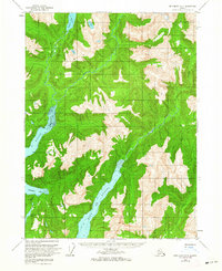
1955 Map of Ketchikan B-2
USGS Topo · Published 1964About this map
The deep saltwater fjords of Boca De Quadra and Wilson Arm penetrate this coastal wilderness in the mid-1950s, defining a landscape of steep timbered ridges within the Tongass National Forest. The map shows a complex drainage system where the Blossom River and Wilson River converge near the head of the arm, a critical interface between glacial-fed freshwater and the sea.
Find a feature on this map
14 named features on this map. Tap any name to fly to it.
Don’t see what you’re looking for? This feature index may not catch every label — zoom into the map to look around manually.
Map Details
Editions of this 1955 Ketchikan B-2 Map
5 editions found
Other maps of this area

1952 · Ketchikan
USGS Topo · 1:250,000

1955 · Ketchikan A-2
USGS Topo · 1:63,360

1955 · Ketchikan C-3
USGS Topo · 1:63,360

1955 · Ketchikan A-1
USGS Topo · 1:63,360

1955 · Ketchikan C-2
USGS Topo · 1:63,360

1955 · Ketchikan B-2
USGS Topo · 1:63,360

1955 · Ketchikan B-1
USGS Topo · 1:63,360

1955 · Ketchikan A-3
USGS Topo · 1:63,360

1955 · Ketchikan B-3
USGS Topo · 1:63,360

1955 · Ketchikan C-1
USGS Topo · 1:63,360