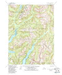
1955 Map of Ketchikan B-2
USGS Topo · Published 1988About this map
Boca De Quadra cuts deep into the southern portion of this landscape, flanked by the steep mountain terrain of the Misty Fjords National Monument Wilderness. The map reveals a complex system of drainage and glacial valleys, where the Blossom River and Keta River feed into the surrounding fjords. This area, part of the Tongass National Forest, remained largely inaccessible by road, defined instead by its waterways and isolated peaks like Quartz Hill.
Find a feature on this map
18 named features on this map. Tap any name to fly to it.
Don’t see what you’re looking for? This feature index may not catch every label — zoom into the map to look around manually.
Map Details
Editions of this 1955 Ketchikan B-2 Map
5 editions found
Other maps of this area

1952 · Ketchikan
USGS Topo · 1:250,000

1955 · Ketchikan A-2
USGS Topo · 1:63,360

1955 · Ketchikan C-3
USGS Topo · 1:63,360

1955 · Ketchikan A-1
USGS Topo · 1:63,360

1955 · Ketchikan C-2
USGS Topo · 1:63,360

1955 · Ketchikan B-2
USGS Topo · 1:63,360

1955 · Ketchikan B-1
USGS Topo · 1:63,360

1955 · Ketchikan A-3
USGS Topo · 1:63,360

1955 · Ketchikan B-3
USGS Topo · 1:63,360

1955 · Ketchikan C-1
USGS Topo · 1:63,360