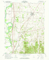
1961 Map of Kingston
USGS Topo · Published 1973About this map
Kingston serves as a central hub on this 1961 landscape, where the Norfolk and Western and Chesapeake and Ohio railroads converge amid the fertile grounds of Ross and Pickaway counties. The area's spiritual and educational history is well-documented through a network of rural landmarks, including Crouse Chapel, Bethel Chapel, and Centralia School. To the west, the Scioto River carves a path through the Union district, bordering the archaeological significance of the Mound City Group National Monument. High points like Sugarloaf and Bald Hill rise above the drainage of Kinnikinnick Creek, illustrating the varied topography that defined local land use and settlement patterns before the expansion of modern highways. This survey also records numerous family and community burial sites, such as Mt Pleasant Cemetery and Miller Cemetery, offering essential points of reference for genealogical research.
Find a feature on this map
53 named features on this map. Tap any name to fly to it.
Don’t see what you’re looking for? This feature index may not catch every label — zoom into the map to look around manually.
Map Details
Editions of this 1961 Kingston Map
4 editions found
Other maps of this area

1906 · Chillicothe
USGS Topo · 1:62,500

1908 · Chillicothe
USGS Topo · 1:62,500

1911 · Era
USGS Topo · 1:62,500

1912 · Roxabell
USGS Topo · 1:62,500

1913 · Era
USGS Topo · 1:62,500

1914 · Roxabell
USGS Topo · 1:62,500

1914 · Circleville
USGS Topo · 1:62,500

1943 · Era
USGS Topo · 1:62,500

1943 · Circleville
USGS Topo · 1:62,500

1944 · Roxabell
USGS Topo · 1:62,500