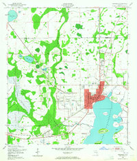
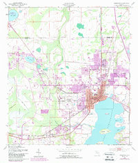
1953 Map of Kissimmee
USGS Topo · Published 1965About this map
The northern shores of Lake Tohopekaliga anchor this mid-century portrait of Kissimmee, showing a community still deeply connected to its wetlands and waterways before the era of major theme park expansion. The city center is densely detailed, featuring the local Courthouse, City Hall, and the Osceola Hospital, while the Kissimmee Airport dominates the land to the west. Significant local heritage is visible in the placement of the Macedonia Ch and Shingle Creek Ch, alongside family-named landmarks like Rosehill Cem and Howard Cem. To the south, the settlement of Campbell sits along the Atlantic Coast Line railroad, reflecting the importance of rail transport for both passengers and the region's agricultural interests. The landscape is a complex network of marshes and islands, including Pine Island and the Cabbage Islands, showing the intricate drainage patterns of Shingle Creek and Reedy Creek as they flow toward the lake.
Find a feature on this map
36 named features on this map. Tap any name to fly to it.
Don’t see what you’re looking for? This feature index may not catch every label — zoom into the map to look around manually.
Map Details
Editions of this 1953 Kissimmee Map
6 editions found
Other maps of this area

1953 · Lake Jessamine
USGS Topo · 1:24,000

1953 · St Cloud North
USGS Topo · 1:24,000

1953 · St Cloud South
USGS Topo · 1:24,000

1953 · Lake Tohopekaliga
USGS Topo · 1:24,000

1953 · Pine Castle
USGS Topo · 1:24,000

1953 · Kissimmee
USGS Topo · 1:24,000

1953 · Windermere
USGS Topo · 1:24,000

1953 · Intercession City
USGS Topo · 1:24,000

1953 · Davenport
USGS Topo · 1:24,000

1955 · Orlando
USGS Topo · 1:250,000