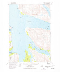
1952 Map of Kodiak C-6
USGS Topo · Published 1977About this map
Larsen Bay serves as the primary outpost of human activity on this stretch of Kodiak Island, where the economy and community revolve around the maritime landscape. The village site is densely packed with infrastructure, including Radio Towers, an Aqueduct, a Cem, and a prominent Cannery, reflecting the area's deep ties to the commercial fishing industry during the mid-20th century. The intricate shoreline of Uyak Bay and Zachar Bay is dotted with numerous cabins, indicating a pattern of seasonal use or remote trapping and fishing sites tucked into protected coves like Chief Cove.
Find a feature on this map
41 named features on this map. Tap any name to fly to it.
Don’t see what you’re looking for? This feature index may not catch every label — zoom into the map to look around manually.
Map Details
Editions of this 1952 Kodiak C-6 Map
3 editions found

Other maps of this area

1951 · Karluk
USGS Topo · 1:250,000

1951 · Kodiak D-6
USGS Topo · 1:63,360

1952 · Kodiak
USGS Topo · 1:250,000

1952 · Karluk
USGS Topo · 1:250,000

1952 · Kodiak B-6
USGS Topo · 1:63,360

1952 · Karluk B-1
USGS Topo · 1:63,360

1952 · Kodiak C-5
USGS Topo · 1:63,360

1952 · Kodiak D-5
USGS Topo · 1:63,360

1952 · Kodiak B-5
USGS Topo · 1:63,360

1952 · Karluk C-1
USGS Topo · 1:63,360