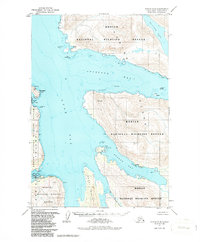
1952 Map of Kodiak C-6
USGS Topo · Published 1987About this map
Larsen Bay serves as a primary coastal anchor on the southwestern reaches of this survey, set against the protected waters of Uyak Bay. The settlement’s infrastructure in the early 1950s is remarkably clear, showing a Landing Strip, Radio Towers, and a designated Cem alongside local maritime facilities. This coastal landscape is defined by deep fjords and maritime navigation points, where the Kodiak National Wildlife Refuge encompasses nearly the entire terrestrial area, including the mountainous interior around Spiridon Lake. To the east, Zachar Bay reveals the specialized infrastructure of the era, notably a Seaplane Base tucked into its southern shore. The map details a complex network of coastal landmarks used for local travel and industry, from the sheltered anchorage at Chief Cove to the narrow passage flanking Amook Island. Small coastal improvements, such as the wharf and buildings near the bay, suggest a landscape tied closely to the seasonal rhythms of Alaskian fishing and aviation.
Find a feature on this map
26 named features on this map. Tap any name to fly to it.
Don’t see what you’re looking for? This feature index may not catch every label — zoom into the map to look around manually.
Map Details
Editions of this 1952 Kodiak C-6 Map
3 editions found

Other maps of this area

1951 · Karluk
USGS Topo · 1:250,000

1951 · Kodiak D-6
USGS Topo · 1:63,360

1952 · Kodiak
USGS Topo · 1:250,000

1952 · Karluk
USGS Topo · 1:250,000

1952 · Kodiak B-6
USGS Topo · 1:63,360

1952 · Karluk B-1
USGS Topo · 1:63,360

1952 · Kodiak C-5
USGS Topo · 1:63,360

1952 · Kodiak D-5
USGS Topo · 1:63,360

1952 · Kodiak B-5
USGS Topo · 1:63,360

1952 · Karluk C-1
USGS Topo · 1:63,360