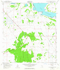
1952 Map of Lake Weohyakapka SE
USGS Topo · Published 1964About this map
Lake Kissimmee and the surrounding marshlands of central Florida define this 1952 topographic study, showing a landscape shaped by water and early transportation infrastructure. The map details the transition from open water to seasonal wetlands, specifically identifying the prominent landmass of Brahma Island and the northern reach of Tiger Lake. Evidence of former industrial activity remains visible through the Old Railroad Grade, which cuts diagonally across the southern terrain, providing a clear path through the hammocks and sloughs that dominate the area. The boundary between Osceola and Polk counties runs through the waters of the lake, while drainage patterns like Buttermilk Slough illustrate the natural hydrology of the region before modern water management systems significantly altered the flow toward the Everglades.
Find a feature on this map
6 named features on this map. Tap any name to fly to it.
Don’t see what you’re looking for? This feature index may not catch every label — zoom into the map to look around manually.
Map Details
Editions of this 1952 Lake Weohyakapka SE Map
5 editions found
Other maps of this area

1952 · Lake Weohyakapka SE
USGS Topo · 1:24,000

1952 · Lake Weohyakapka NE
USGS Topo · 1:24,000

1952 · Fort Kissimmee NW
USGS Topo · 1:24,000

1952 · Lake Arbuckle NE
USGS Topo · 1:24,000

1952 · Hesperides
USGS Topo · 1:24,000

1952 · Lake Arbuckle
USGS Topo · 1:24,000

1952 · Lake Weohyakapka
USGS Topo · 1:24,000

1953 · Lake Marian NW
USGS Topo · 1:24,000

1953 · Lake Marian SW
USGS Topo · 1:24,000

1956 · Fort Pierce
USGS Topo · 1:250,000