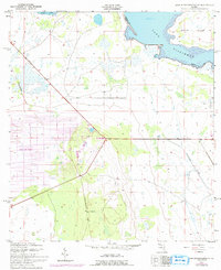
1952 Map of Lake Weohyakapka SE
USGS Topo · Published 1993About this map
Indian Lake Estates occupies a sprawling surveyed grid in this central Florida landscape, illustrating mid-century residential planning amidst the wetlands and lakes of Polk County. The terrain is defined by its significant water bodies, including the southern reaches of Tiger Lake and the expansive Lake Kissimmee, which contains the prominent Brahma Island. A distinctive diagonal line traces the Old Railroad Grade, a clear indication of earlier industrial or transport efforts that preceded the modern residential developments. The area's drainage is further marked by the winding path of Buttermilk Slough near the border of Osceola County. This survey reflects a period of transition where traditional citrus and cattle lands began to interface with large-scale subdivided property ventures.
Find a feature on this map
8 named features on this map. Tap any name to fly to it.
Don’t see what you’re looking for? This feature index may not catch every label — zoom into the map to look around manually.
Map Details
Editions of this 1952 Lake Weohyakapka SE Map
5 editions found
Other maps of this area

1952 · Lake Weohyakapka SE
USGS Topo · 1:24,000

1952 · Lake Weohyakapka NE
USGS Topo · 1:24,000

1952 · Fort Kissimmee NW
USGS Topo · 1:24,000

1952 · Lake Arbuckle NE
USGS Topo · 1:24,000

1952 · Hesperides
USGS Topo · 1:24,000

1952 · Lake Arbuckle
USGS Topo · 1:24,000

1952 · Lake Weohyakapka
USGS Topo · 1:24,000

1953 · Lake Marian NW
USGS Topo · 1:24,000

1953 · Lake Marian SW
USGS Topo · 1:24,000

1956 · Fort Pierce
USGS Topo · 1:250,000