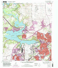
1955 Map of Lake Worth
USGS Topo · Published 1982About this map
Carswell Air Force Base and the adjacent Air Force Plant 4 dominate the southern half of this landscape, illustrating the Cold War-era military and industrial expansion northwest of Fort Worth. The topography captures a period of significant growth in suburban settlements like White Settlement, River Oaks, and Sansom Park Village, while the surrounding Fort Worth City Park areas preserve the recreational character of the lakefront.
Find a feature on this map
50 named features on this map. Tap any name to fly to it.
Don’t see what you’re looking for? This feature index may not catch every label — zoom into the map to look around manually.
Map Details
Editions of this 1955 Lake Worth Map
5 editions found

Other maps of this area

1891 · Weatherford
USGS Topo · 1:125,000

1893 · Weatherford
USGS Topo · 1:125,000

1894 · Fort Worth
USGS Topo · 1:125,000

1932 · Springtown
USGS Topo · 1:62,500

1954 · Dallas
USGS Topo · 1:250,000

1955 · Haltom City
USGS Topo · 1:24,000

1955 · Avondale
USGS Topo · 1:24,000

1955 · Aledo
USGS Topo · 1:24,000

1955 · Azle
USGS Topo · 1:24,000

1955 · Keller
USGS Topo · 1:24,000