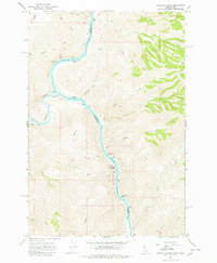
1968 Map of Limekiln Rapids
USGS Topo · Published 1980About this map
Rogersburg sits at the confluence where the Grande Ronde River meets the Snake River, marking a critical juncture at the border of Washington and Idaho. The river corridor is defined by a series of significant whitewater features, including Captain Lewis Rapids, Limekiln Rapids, and Negro Head Rapids, which speak to the historic navigational challenges of this canyon reach. A Gaging Station located near the river bend provides a clue to the hydrological monitoring necessary for this powerful waterway.
Find a feature on this map
31 named features on this map. Tap any name to fly to it.
Don’t see what you’re looking for? This feature index may not catch every label — zoom into the map to look around manually.
Map Details
Editions of this 1968 Limekiln Rapids Map
3 editions found
Other maps of this area

1944 · Anatone
USGS Topo · 1:62,500

1946 · Limekiln Rapids
USGS Topo · 1:62,500

1946 · Anatone
USGS Topo · 1:62,500

1955 · Pullman
USGS Topo · 1:250,000

1955 · Grangeville
USGS Topo · 1:250,000

1958 · Pullman
USGS Topo · 1:250,000

1959 · Grangeville
USGS Topo · 1:250,000

1963 · Jim Creek Butte
USGS Topo · 1:24,000

1963 · Wapshilla Creek
USGS Topo · 1:24,000
1967 · Teepee Butte
USGS Topo · 1:24,000