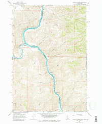
1968 Map of Limekiln Rapids
USGS Topo · Published 1980About this map
Rogersburg stands at the confluence where the Grande Ronde River meets the northward flow of the Snake River on this Idaho-Washington borderland study. The river corridor is defined by a series of treacherous navigation points, including Captain Lewis Rapids, Limekiln Rapids, and Wild Goose Rapids, reflecting the challenging river-based transport economy of the mid-twentieth century. Away from the water, the landscape rises sharply toward Montgomery Ridge and Limestone Point, cut by deep gulches like Fisher Gulch and Perkins Gulch. A solitary Prospect near the riverbank and a Gaging Station indicate the modest industrial and monitoring activities present in this sparsely settled canyon reach. The network of unimproved dirt roads provides a look at the remote access patterns before modern developments altered the character of the Nez Perce and Asotin county border.
Find a feature on this map
35 named features on this map. Tap any name to fly to it.
Don’t see what you’re looking for? This feature index may not catch every label — zoom into the map to look around manually.
Map Details
Editions of this 1968 Limekiln Rapids Map
3 editions found
Other maps of this area

1944 · Anatone
USGS Topo · 1:62,500

1946 · Limekiln Rapids
USGS Topo · 1:62,500

1946 · Anatone
USGS Topo · 1:62,500

1955 · Pullman
USGS Topo · 1:250,000

1955 · Grangeville
USGS Topo · 1:250,000

1958 · Pullman
USGS Topo · 1:250,000

1959 · Grangeville
USGS Topo · 1:250,000

1963 · Jim Creek Butte
USGS Topo · 1:24,000

1963 · Wapshilla Creek
USGS Topo · 1:24,000
1967 · Teepee Butte
USGS Topo · 1:24,000