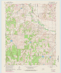
1966 Map of Lindsay SW
USGS Topo · Published 1984About this map
The Washita River meanders across the northern portion of this Oklahoma landscape, defining the boundary between Grady and McClain counties. Near the settlement of Bradley, the Gulf Colorado and Santa Fe Railroad tracks parallel the waterway, marking the importance of rail transport for this agricultural and industrial corridor in the mid-1960s. The presence of a Refinery, Radio Tower, and Water Tank south of the river suggests a pocket of industrial activity amidst the surrounding rural townships.
Find a feature on this map
24 named features on this map. Tap any name to fly to it.
Don’t see what you’re looking for? This feature index may not catch every label — zoom into the map to look around manually.
Map Details
Editions of this 1966 Lindsay SW Map
3 editions found
Other maps of this area

1902 · Rush Springs
USGS Topo · 1:125,000

1949 · Rush Springs
USGS Topo · 1:62,500

1950 · Rush Springs
USGS Topo · 1:62,500

1950 · Marlow
USGS Topo · 1:62,500

1951 · Marlow
USGS Topo · 1:62,500

1957 · Ardmore
USGS Topo · 1:250,000

1963 · Ardmore
USGS Topo · 1:250,000

1966 · Lindsay
USGS Topo · 1:24,000
1966 · Criner
USGS Topo · 1:24,000

1966 · Lindsay SW
USGS Topo · 1:24,000