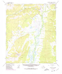
1953 Map of Livengood B-4
USGS Topo · Published 1978About this map
Tolovana River and its various tributaries define this mid-century Alaskan interior, captured here as modern infrastructure began to intersect with the wilderness. The map documents a significant industrial milestone with the Trans-Alaska Pipeline (Under Construction) cutting through the drainage basins of Vigor Creek and Brooks Creek. This corridor parallels an established tractor trail, highlighting the evolution of transport in the region from rugged overland routes to major energy infrastructure.
Find a feature on this map
25 named features on this map. Tap any name to fly to it.
Don’t see what you’re looking for? This feature index may not catch every label — zoom into the map to look around manually.
Map Details
Editions of this 1953 Livengood B-4 Map
3 editions found
Other maps of this area

1945 · Livengood
USGS Topo · 1:250,000

1951 · Livengood
USGS Topo · 1:250,000

1951 · Livengood A-5
USGS Topo · 1:63,360

1951 · Livengood A-4
USGS Topo · 1:63,360

1952 · Livengood C-5
USGS Topo · 1:63,360

1952 · Livengood B-5
USGS Topo · 1:63,360

1952 · Livengood C-4
USGS Topo · 1:63,360

1953 · Livengood B-4
USGS Topo · 1:63,360

1953 · Livengood A-4
USGS Topo · 1:63,360

1953 · Livengood A-3
USGS Topo · 1:63,360