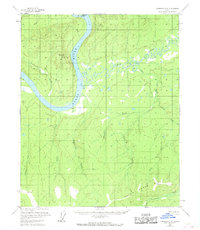
1956 Map of Livengood C-6
USGS Topo · Published 1968About this map
The Yukon River dominates this landscape, sweeping through the terrain past Crescent Island and several small riverside Cabin sites. This 1950s-era topography reveals a remote wilderness defined by an intricate network of drainages, where the Drew Mine is located near Maypole Hill. The map detail suggests a reliance on river access and seasonal resource extraction, as various unnamed trails and cabins are scattered among the ridges.
Find a feature on this map
17 named features on this map. Tap any name to fly to it.
Don’t see what you’re looking for? This feature index may not catch every label — zoom into the map to look around manually.
Map Details
Editions of this 1956 Livengood C-6 Map
3 editions found
Other maps of this area

1945 · Livengood
USGS Topo · 1:250,000

1951 · Tanana
USGS Topo · 1:250,000

1951 · Livengood
USGS Topo · 1:250,000

1952 · Livengood C-5
USGS Topo · 1:63,360

1952 · Livengood B-5
USGS Topo · 1:63,360

1952 · Livengood D-5
USGS Topo · 1:63,360

1956 · Tanana B-1
USGS Topo · 1:63,360

1956 · Tanana C-1
USGS Topo · 1:63,360

1956 · Livengood B-6
USGS Topo · 1:63,360

1956 · Livengood C-6
USGS Topo · 1:63,360