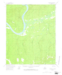
1956 Map of Livengood C-6
USGS Topo · Published 1968About this map
The Yukon River carves a massive bend through this interior Alaskan wilderness, encircling Crescent Island and dominating the northwestern landscape. During the mid-1950s, this area remained largely undeveloped, characterized by a dense network of watercourses including Hess Creek and Raven Creek. The human presence is sparse, marked primarily by a single Cabin near the riverbank and the Drew Mine, which signifies the region's intermittent history of resource extraction. Geodetic markers like VABM 1724 Bend on Maypole Hill and VABM 2384 Raven provide fixed points across the drainage basins of McDermott Creek and Whymper Creek. The map documents a landscape of swampy lowlands and complex creek systems before any significant modern road infrastructure reached this section of the Yukon-Koyukuk region.
Find a feature on this map
19 named features on this map. Tap any name to fly to it.
Don’t see what you’re looking for? This feature index may not catch every label — zoom into the map to look around manually.
Map Details
Editions of this 1956 Livengood C-6 Map
3 editions found
Other maps of this area

1945 · Livengood
USGS Topo · 1:250,000

1951 · Tanana
USGS Topo · 1:250,000

1951 · Livengood
USGS Topo · 1:250,000

1952 · Livengood C-5
USGS Topo · 1:63,360

1952 · Livengood B-5
USGS Topo · 1:63,360

1952 · Livengood D-5
USGS Topo · 1:63,360

1956 · Tanana B-1
USGS Topo · 1:63,360

1956 · Tanana C-1
USGS Topo · 1:63,360

1956 · Livengood B-6
USGS Topo · 1:63,360

1956 · Livengood C-6
USGS Topo · 1:63,360