1985 Map of Llano
USGS Topo · Published 1985About this map
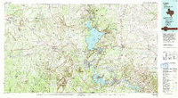
Lake Buchanan and the Colorado River define the eastern landscape of this 1985 Llano quadrangle, where the Texas Hill Country meets the Highland Lakes. The map illustrates a region transitioning from rural agricultural roots to a recreation-centered economy, evidenced by the clustered developments of Sunrise Beach Village and Granite Shoals along the water's edge. Significant geological landmarks like Enchanted Rock State Park and Longhorn Cavern State Park highlight the area's unique topography, while the Southern Pacific rail line cuts through the eastern settlements near Burnet.
Find a feature on this map
243 named features on this map. Tap any name to fly to it.
Don’t see what you’re looking for? This feature index may not catch every label — zoom into the map to look around manually.
Map Details
Editions of this 1985 Llano Map
This is the sole edition of this map. No revisions or reprints were ever made.
Historical Maps of Marble Falls Through Time
10 maps found