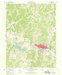
1961 Map of Logan
USGS Topo · Published 1969About this map
Logan serves as the focal point of this Hocking County survey, established at the junction where Clear Fork and Scott Creek meet the winding Hocking River. The town's early 1960s footprint is defined by its central Courthouse, the County Fairground, and a series of industrial Kilns near the riverbanks. The transportation corridor follows the Chesapeake and Ohio railway line, which parallels the river through West Logan and Enterprise. Beyond the urban center, the landscape is dotted with rural markers of community life, including Mt Tabor Ch, Marion Sch, and numerous family burial grounds like Ruff Cem and Dunkard Cem. The presence of a Strip Mine and a Gravel Pit along the eastern boundaries suggests the local extraction economy, while Hocking County Lake provides a significant water feature amidst the complex network of ridges like Calico Ridge.
Find a feature on this map
64 named features on this map. Tap any name to fly to it.
Don’t see what you’re looking for? This feature index may not catch every label — zoom into the map to look around manually.
Map Details
Editions of this 1961 Logan Map
4 editions found
Other maps of this area

1904 · Zaleski
USGS Topo · 1:62,500

1907 · Zaleski
USGS Topo · 1:62,500

1907 · Logan
USGS Topo · 1:62,500

1907 · Lancaster
USGS Topo · 1:62,500

1909 · Lancaster
USGS Topo · 1:62,500

1909 · Logan
USGS Topo · 1:62,500

1910 · Laurelville
USGS Topo · 1:62,500

1912 · Laurelville
USGS Topo · 1:62,500

1944 · Laurelville
USGS Topo · 1:62,500

1947 · Columbus
USGS Topo · 1:250,000