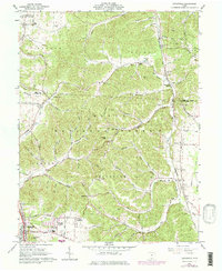
1961 Map of Lucasville
USGS Topo · Published 1977About this map
Wayne National Forest dominates the central landscape of this southern Ohio survey, where the complex ridge-and-hollow topography is defined by the winding drainages of Salt Creek and Pecks Creek. In the southwest corner, the growing community of Lucasville is marked by the Preston Addition and Tomlinson Addition, serving as a hub near the intersection of the Norfolk and Western and Chesapeake and Ohio railroads. The area's industrial character is highlighted by several Claypits and a sprawling U S Reservation Atomic Energy Commission site in the northwest. Local life is documented through scattered landmarks such as Victory Chapel and the Valley Local High Sch, alongside numerous small family burial grounds including Slavens Cem and Adams Cem.
Find a feature on this map
93 named features on this map. Tap any name to fly to it.
Don’t see what you’re looking for? This feature index may not catch every label — zoom into the map to look around manually.
Map Details
Editions of this 1961 Lucasville Map
3 editions found
Other maps of this area

1906 · Waverly
USGS Topo · 1:62,500

1908 · Waverly
USGS Topo · 1:62,500

1911 · Sciotoville
USGS Topo · 1:62,500

1913 · Sciotoville
USGS Topo · 1:62,500

1915 · Otway
USGS Topo · 1:62,500

1915 · Piketon
USGS Topo · 1:62,500

1917 · Piketon
USGS Topo · 1:62,500

1917 · Otway
USGS Topo · 1:62,500

1944 · Piketon
USGS Topo · 1:62,500

1947 · Columbus
USGS Topo · 1:250,000