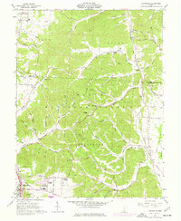
1961 Map of Lucasville
USGS Topo · Published 1977About this map
The Scioto River valley and the rugged interior of the Wayne National Forest dominate this early 1960s study of southern Ohio. Settlement is concentrated along the river corridor in Lucasville, where residential growth is visible in the Preston Addition and Tomlison Addition. The landscape is a complex network of hollows and runs, such as Coon Hollow and Cockrell Run, that historically dictated the placement of small rural communities like Rapp and Golddust.
Find a feature on this map
102 named features on this map. Tap any name to fly to it.
Don’t see what you’re looking for? This feature index may not catch every label — zoom into the map to look around manually.
Map Details
Editions of this 1961 Lucasville Map
3 editions found
Other maps of this area

1906 · Waverly
USGS Topo · 1:62,500

1908 · Waverly
USGS Topo · 1:62,500

1911 · Sciotoville
USGS Topo · 1:62,500

1913 · Sciotoville
USGS Topo · 1:62,500

1915 · Otway
USGS Topo · 1:62,500

1915 · Piketon
USGS Topo · 1:62,500

1917 · Piketon
USGS Topo · 1:62,500

1917 · Otway
USGS Topo · 1:62,500

1944 · Piketon
USGS Topo · 1:62,500

1947 · Columbus
USGS Topo · 1:250,000