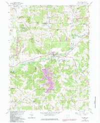
1960 Map of Malvern
USGS Topo · Published 1985About this map
Malvern and Waynesburg anchor this map of the Stark Co Carroll Co borderlands, where the Norfolk and Western Railway follows the path of Sandy Creek. The landscape is a mix of industrial legacy and community markers, including numerous Strip Mines and the Brickkilns site near Oneida. The 1980s updates in purple highlight the creation of Mohawk Lake along Middle Run, which significantly altered the local drainage. Cultural landmarks such as St Marys Ch, Salem Ch, and the Bethlehem Cem provide essential anchor points for genealogists tracing families in the townships of Rose, Brown, and Osnaburg. Small, specific locations like Fritchleys Corners and the Minerva Airfield show the diverse rural activity of the era.
Find a feature on this map
55 named features on this map. Tap any name to fly to it.
Don’t see what you’re looking for? This feature index may not catch every label — zoom into the map to look around manually.
Map Details
Editions of this 1960 Malvern Map
4 editions found
Other maps of this area

1901 · Canton
USGS Topo · 1:62,500

1903 · Canton
USGS Topo · 1:62,500

1909 · Alliance
USGS Topo · 1:62,500

1910 · Carrollton
USGS Topo · 1:62,500

1912 · Dover
USGS Topo · 1:62,500

1912 · Carrollton
USGS Topo · 1:62,500

1944 · Dover
USGS Topo · 1:62,500

1951 · Canton
USGS Topo · 1:250,000

1953 · Canton
USGS Topo · 1:250,000

1957 · Canton
USGS Topo · 1:250,000