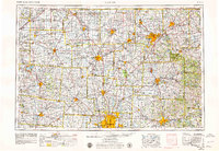
1966 Map of Marion
USGS Topo · Published 1979About this map
The Scioto River and Olentangy River corridors anchor this mid-century survey of Central Ohio, revealing a landscape defined by its river-valley settlements and burgeoning post-war infrastructure. Large urban centers like Columbus, Marion, and Mansfield are shown at a pivotal moment of expansion, connected by the growing interstate system of I-71 and I-70. The map documents significant institutional footprints, including the State Reformatory near Shelby and the campus of Ohio State University.
Find a feature on this map
68 named features on this map. Tap any name to fly to it.
Don’t see what you’re looking for? This feature index may not catch every label — zoom into the map to look around manually.
Map Details
Editions of this 1966 Marion Map
3 editions found

Other maps of this area

1901 · Dublin
USGS Topo · 1:62,500

1901 · Fostoria
USGS Topo · 1:62,500

1901 · Wooster
USGS Topo · 1:62,500

1902 · Westerville
USGS Topo · 1:62,500

1903 · Wooster
USGS Topo · 1:62,500

1903 · Dublin
USGS Topo · 1:62,500

1903 · Fostoria
USGS Topo · 1:62,500

1903 · Findlay
USGS Topo · 1:62,500

1903 · Marion
USGS Topo · 1:62,500

1904 · Westerville
USGS Topo · 1:62,500