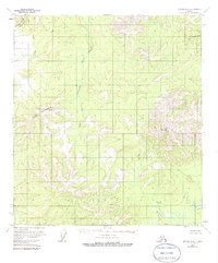
1954 Map of Medfra B-6
USGS Topo · Published 1986About this map
Susulatna River and the Agate Fork dominate this interior landscape, cutting through an area defined by significant relief and unsurveyed land lines. Mapped from aerial photographs taken in the mid-1950s, the terrain transitions from the low-lying wetlands and swamps near the riverbanks to the prominent heights of Fossil Mountain and Page Mountain. The northwest corner is anchored by the Cripple Mountains, where Cripple Creek and Canyon Creek descend into the valleys. This region is notably devoid of established roads or permanent settlements during this period, emphasizing the wilderness character of the Yukon-Koyukuk interior. The drainage pattern of the West Fork Nixon Fork in the northeast further illustrates the complex watershed system that shapes this remote Alaskan territory.
Find a feature on this map
8 named features on this map. Tap any name to fly to it.
Don’t see what you’re looking for? This feature index may not catch every label — zoom into the map to look around manually.
Map Details
Editions of this 1954 Medfra B-6 Map
3 editions found
Other maps of this area

1950 · Medfra
USGS Topo · 1:250,000

1951 · Ophir
USGS Topo · 1:250,000

1953 · Medfra B-5
USGS Topo · 1:63,360

1954 · Medfra A-6
USGS Topo · 1:63,360

1954 · Medfra A-5
USGS Topo · 1:63,360

1954 · Ophir A-1
USGS Topo · 1:63,360

1954 · Medfra C-6
USGS Topo · 1:63,360

1954 · Medfra C-5
USGS Topo · 1:63,360

1954 · Medfra B-6
USGS Topo · 1:63,360

1954 · Ophir C-1
USGS Topo · 1:63,360