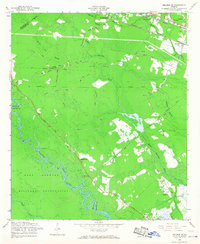
1958 Map of Meldrim SE
USGS Topo · Published 1968About this map
The Ogeechee River and its intricate network of drainage canals define this 1958 landscape on the edge of Savannah. The map documents a transition from the agricultural heritage of the Hopeton Plantation and the historic Savannah Canal and Ogeechee Canal to the mid-century expansion of Bloomingdale and Pooler. Significant portions of the western terrain are occupied by the Fort Stewart Military Reservation, while the Central of Georgia and Seaboard Air Line railroads provide the primary industrial corridors through the low-lying swamplands. Genealogists will find a wealth of specific landmarks, including the Brickyard Cem, the U.S. Dept of Agriculture Plant Introduction Garden, and several rural churches like South Newington Ch and Saint John Ch that anchored these local communities before suburban growth intensified.
Find a feature on this map
43 named features on this map. Tap any name to fly to it.
Don’t see what you’re looking for? This feature index may not catch every label — zoom into the map to look around manually.
Map Details
Editions of this 1958 Meldrim SE Map
4 editions found
Other maps of this area

1920 · Meldrim
USGS Topo · 1:62,500

1920 · Limerick
USGS Topo · 1:62,500

1942 · Meldrim
USGS Topo · 1:62,500

1942 · Savannah
USGS Topo · 1:62,500

1944 · Limerick
USGS Topo · 1:62,500

1944 · Ossabaw Island
USGS Topo · 1:62,500

1945 · Ossabaw Island
USGS Topo · 1:62,500

1946 · Brunswick
USGS Topo · 1:250,000

1947 · Savannah
USGS Topo · 1:250,000

1948 · Brunswick
USGS Topo · 1:250,000