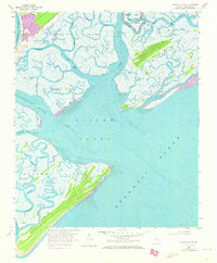
1957 Map of Wassaw Sound
USGS Topo · Published 1973About this map
The Fort Pulaski National Monument stands as a sentinel at the northern edge of this coastal landscape, where the Lazaretto Creek and Tybee Creek meet the tidal marshes of the Georgia coast. This 1957 survey, updated with 1971 aerial data, reveals a complex network of waterways including the Wilmington River and the Odingsell River, defining a series of barrier islands and marshlands. The mapping captures the intricate drainage patterns of the Romerly Marsh Creek and the expansive Wassaw Sound, which separates the northern islands from the densely vegetated Wassaw Island.
Find a feature on this map
34 named features on this map. Tap any name to fly to it.
Don’t see what you’re looking for? This feature index may not catch every label — zoom into the map to look around manually.
Map Details
Editions of this 1957 Wassaw Sound Map
3 editions found
Other maps of this area

1920 · Wassaw Sound
USGS Topo · 1:62,500

1920 · Bluffton
USGS Topo · 1:62,500

1942 · Savannah
USGS Topo · 1:62,500

1944 · Ossabaw Island
USGS Topo · 1:62,500

1945 · Bluffton
USGS Topo · 1:62,500

1945 · Ossabaw Island
USGS Topo · 1:62,500

1945 · Wassaw Sound
USGS Topo · 1:62,500

1946 · Brunswick
USGS Topo · 1:250,000

1947 · Savannah
USGS Topo · 1:250,000

1948 · Brunswick
USGS Topo · 1:250,000