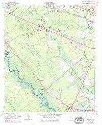
1958 Map of Meldrim SE
USGS Topo · Published 1977About this map
Hopeton Plantation and its associated Hopeton Plantation Cem sit near the southeastern edge of this coastal Georgia landscape, a region defined by extensive wetlands and an intricate network of man-made waterways. The Ogeechee River and Little Ogeechee River meander through the terrain, flanked by the Hardin Canal, Savannah Canal, and Quacco Canal. These drainage systems reveal the mid-century efforts to manage the low-lying Hardin Swamp and Horse Pen Swamp for agricultural and industrial use.
Find a feature on this map
42 named features on this map. Tap any name to fly to it.
Don’t see what you’re looking for? This feature index may not catch every label — zoom into the map to look around manually.
Map Details
Editions of this 1958 Meldrim SE Map
4 editions found
Other maps of this area

1920 · Meldrim
USGS Topo · 1:62,500

1920 · Limerick
USGS Topo · 1:62,500

1942 · Meldrim
USGS Topo · 1:62,500

1942 · Savannah
USGS Topo · 1:62,500

1944 · Limerick
USGS Topo · 1:62,500

1944 · Ossabaw Island
USGS Topo · 1:62,500

1945 · Ossabaw Island
USGS Topo · 1:62,500

1946 · Brunswick
USGS Topo · 1:250,000

1947 · Savannah
USGS Topo · 1:250,000

1948 · Brunswick
USGS Topo · 1:250,000