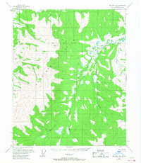
1956 Map of Melozitna B-2
USGS Topo · Published 1967About this map
The Little Melozitna River meanders through this interior Alaskan wilderness, defined by a network of drainage basins including Eureka Creek and Hudson Creek. Surveyed in the mid-1950s using photogrammetric methods from aerial photographs, the topography reveals a complex landscape of unnamed ridges and marshy lowlands typical of the Yukon-Koyukuk region. The map captures critical surveying markers like the Kateel River Base Line and the high elevation points of VABM 3478 Rocky and VABM 2833 Green. The presence of the Shorines and numerous marshy pockets alongside Moran Creek indicates a landscape shaped by seasonal water fluctuations and permafrost conditions. This record serves as a baseline for the region before modern development, showing the area as it appeared during the height of mid-century aerial surveying efforts by the Geological Survey.
Find a feature on this map
10 named features on this map. Tap any name to fly to it.
Don’t see what you’re looking for? This feature index may not catch every label — zoom into the map to look around manually.
Map Details
Editions of this 1956 Melozitna B-2 Map
2 editions found
Other maps of this area

1951 · Melozitna
USGS Topo · 1:250,000

1952 · Melozitna A-2
USGS Topo · 1:63,360

1952 · Melozitna A-1
USGS Topo · 1:63,360

1953 · Melozitna A-2
USGS Topo · 1:63,360

1954 · Melozitna B-3
USGS Topo · 1:63,360
1954 · Melozitna A-3
USGS Topo · 1:63,360

1954 · Melozitna C-3
USGS Topo · 1:63,360

1956 · Melozitna B-2
USGS Topo · 1:63,360

1956 · Melozitna C-1
USGS Topo · 1:63,360

1956 · Melozitna B-1
USGS Topo · 1:63,360