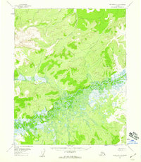
1956 Map of Melozitna C-2
USGS Topo · Published 1959About this map
The Melozitna River meanders across this landscape, defining a broad valley of wetlands and complex oxbows in the central and southern portions of the quadrangle. North of these lowlands, the Little Indian River cuts through higher elevations, while Bacon Creek drains the eastern slopes. The terrain is characterized by significant topographic rises, notably the Krines Hills in the southeast and prominent benchmarks like Vabm 3214 in the northwest. Surveyed by the U.S. Geological Survey using aerial photography from the early to mid-1950s, the map shows an area of Alaska devoid of roads or trails during this period. The intricate drainage patterns and the distinction between the saturated river bottoms and the surrounding high ground provide a clear view of the hydrological character of the region before any modern infrastructure development.
Find a feature on this map
6 named features on this map. Tap any name to fly to it.
Don’t see what you’re looking for? This feature index may not catch every label — zoom into the map to look around manually.
Map Details
Editions of this 1956 Melozitna C-2 Map
2 editions found
Other maps of this area

1951 · Melozitna
USGS Topo · 1:250,000

1952 · Melozitna D-1
USGS Topo · 1:63,360

1952 · Melozitna D-3
USGS Topo · 1:63,360

1954 · Melozitna B-3
USGS Topo · 1:63,360

1954 · Melozitna C-3
USGS Topo · 1:63,360

1954 · Melozitna D-3
USGS Topo · 1:63,360

1955 · Melozitna D-2
USGS Topo · 1:63,360

1956 · Melozitna B-2
USGS Topo · 1:63,360

1956 · Melozitna C-1
USGS Topo · 1:63,360

1956 · Melozitna B-1
USGS Topo · 1:63,360