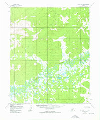
1956 Map of Melozitna C-2
USGS Topo · Published 1976About this map
The Melozitna River winds through a vast complex of wetlands and oxbow lakes in this interior Alaskan wilderness, recorded during aerial surveys in the mid-1950s. The landscape is defined by the sharp contrast between the saturated lowlands of the river basin and the surrounding uplands, including the Kokrines Hills to the south. Tributaries such as the Little Indian River and Bacon Creek feed into the main channel, illustrating the drainage patterns of a region untouched by permanent roads or settlements. High-elevation survey points like VABM 3214 Flat and VABM 1803 Burnt indicate the remote nature of this terrain, where mapmakers relied on photogrammetric methods to document the unsurveyed and unmarked land lines of the Kateel River Meridian.
Find a feature on this map
6 named features on this map. Tap any name to fly to it.
Don’t see what you’re looking for? This feature index may not catch every label — zoom into the map to look around manually.
Map Details
Editions of this 1956 Melozitna C-2 Map
2 editions found
Other maps of this area

1951 · Melozitna
USGS Topo · 1:250,000

1952 · Melozitna D-1
USGS Topo · 1:63,360

1952 · Melozitna D-3
USGS Topo · 1:63,360

1954 · Melozitna B-3
USGS Topo · 1:63,360

1954 · Melozitna C-3
USGS Topo · 1:63,360

1954 · Melozitna D-3
USGS Topo · 1:63,360

1955 · Melozitna D-2
USGS Topo · 1:63,360

1956 · Melozitna B-2
USGS Topo · 1:63,360

1956 · Melozitna C-1
USGS Topo · 1:63,360

1956 · Melozitna B-1
USGS Topo · 1:63,360