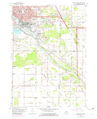
1962 Map of Midland South
USGS Topo · Published 1982About this map
The Tittabawassee River carves a diagonal path through this landscape, serving as a focal point for the industrial and agricultural development of southern Midland. This map reveals a unique chemical-industrial economy defined by dozens of Brine Wells and the large Brine Pond No 6, reflecting the region’s historical reliance on subsurface mineral extraction. The urban expansion of Midland is evident in the northern portion, where numerous parks like Currie Bennett Park and Eastlawn Park sit alongside institutional landmarks such as the High School and City Hall.
Find a feature on this map
84 named features on this map. Tap any name to fly to it.
Don’t see what you’re looking for? This feature index may not catch every label — zoom into the map to look around manually.
Map Details
Editions of this 1962 Midland South Map
4 editions found

Other maps of this area

1917 · St. Charles
USGS Topo · 1:62,500

1934 · Sanford
USGS Topo · 1:62,500

1934 · Merrill
USGS Topo · 1:62,500

1936 · Sanford
USGS Topo · 1:62,500

1937 · Merrill
USGS Topo · 1:62,500

1943 · St. Charles
USGS Topo · 1:62,500

1954 · Midland
USGS Topo · 1:250,000

1958 · Midland
USGS Topo · 1:250,000

1959 · Midland
USGS Topo · 1:250,000

1962 · Willard
USGS Topo · 1:24,000