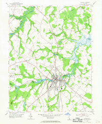
1954 Map of Milford
USGS Topo · Published 1969About this map
Milford serves as the central hub of this mid-century survey, straddling the border between Kent and Sussex counties. The landscape is defined by its sophisticated water management and milling history, centered on the Mispillion River and a network of coastal ponds including Haven Lake, Silver Lake, and Tubmill Pond. The industrial and transportation identity of the era is marked by the Pennsylvania Railroad corridor and the Milford Air Park, indicating a town in transition between traditional maritime commerce and modern aviation. Outside the town center, rural life is anchored by community landmarks like the I O O F Cemetery, Millwood Church, and Old Spring Hill Baptist Church. To the north, the winding Big Murderkill River and its associated guts and branches drain the low-lying Milford Neck, illustrating the intricate relationship between the agricultural district and the Delaware Bay watershed.
Find a feature on this map
53 named features on this map. Tap any name to fly to it.
Don’t see what you’re looking for? This feature index may not catch every label — zoom into the map to look around manually.
Map Details
Editions of this 1954 Milford Map
3 editions found
Other maps of this area

1899 · Vineland
USGS Topo · 1:125,000

1899 · Dover
USGS Topo · 1:125,000

1906 · Dover
USGS Topo · 1:125,000

1918 · Cedar Creek
USGS Topo · 1:62,500

1918 · Harrington
USGS Topo · 1:62,500

1919 · Cedar Creek
USGS Topo · 1:62,500

1919 · Vineland
USGS Topo · 1:125,000

1920 · Dover
USGS Topo · 1:125,000

1926 · Wyoming
USGS Topo · 1:48,000

1930 · Wyoming
USGS Topo · 1:62,500