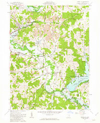
1961 Map of Mineral City
USGS Topo · Published 1963About this map
Strip mines and industrial kilns characterize the hill country surrounding Mineral City in the early 1960s, reflecting a landscape defined by resource extraction and heavy rail transport. The confluence of the Baltimore and Ohio and Pennsylvania railroads served as the pulse of this region, connecting coal and clay production to broader markets. The map captures a complex intersection of historic boundaries, marking where the Old United States Military District Boundary meets the Military Ranges Boundary. To the southeast, the waters of Atwood Reservoir and the Atwood Lake Park represent the era's significant flood control and recreation efforts under the Muskingum Watershed Conservancy District. Scattered rural cemeteries like Deep Springs Cem and Lindentree Cem remain as quiet fixtures among the winding valleys of Conotton Creek and Huff Run.
Find a feature on this map
47 named features on this map. Tap any name to fly to it.
Don’t see what you’re looking for? This feature index may not catch every label — zoom into the map to look around manually.
Map Details
Editions of this 1961 Mineral City Map
4 editions found
Other maps of this area

1902 · Scio
USGS Topo · 1:62,500

1904 · Scio
USGS Topo · 1:62,500

1909 · Uhrichsville
USGS Topo · 1:62,500

1910 · Carrollton
USGS Topo · 1:62,500

1911 · Uhrichsville
USGS Topo · 1:62,500

1912 · Dover
USGS Topo · 1:62,500

1912 · Carrollton
USGS Topo · 1:62,500

1944 · Dover
USGS Topo · 1:62,500

1951 · Canton
USGS Topo · 1:250,000

1951 · Bolivar
USGS Topo · 1:24,000