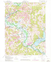
1961 Map of Mineral City
USGS Topo · Published 1972About this map
Strip mines dominate the ridges of this 1961 survey, reflecting the heavy industrial character of the Tuscarawas and Carroll County border during the mid-20th century. While Mineral City and Somerdale serve as the primary residential hubs, the landscape is heavily influenced by the presence of the Muskingum Watershed Conservancy District, particularly around the extensive Atwood Reservoir and Atwood Lake Park. The transport of coal and raw materials is etched into the map through the diverging tracks of the Baltimore and Ohio, Penn Central, and Norfolk and Western railroads. Smaller rural life persists in the valleys, where local families maintained roots at sites like St Matthews Ch Cem and Holmes Ch along the waters of Conotton Creek and Huff Run.
Find a feature on this map
46 named features on this map. Tap any name to fly to it.
Don’t see what you’re looking for? This feature index may not catch every label — zoom into the map to look around manually.
Map Details
Editions of this 1961 Mineral City Map
4 editions found
Other maps of this area

1902 · Scio
USGS Topo · 1:62,500

1904 · Scio
USGS Topo · 1:62,500

1909 · Uhrichsville
USGS Topo · 1:62,500

1910 · Carrollton
USGS Topo · 1:62,500

1911 · Uhrichsville
USGS Topo · 1:62,500

1912 · Dover
USGS Topo · 1:62,500

1912 · Carrollton
USGS Topo · 1:62,500

1944 · Dover
USGS Topo · 1:62,500

1951 · Canton
USGS Topo · 1:250,000

1951 · Bolivar
USGS Topo · 1:24,000