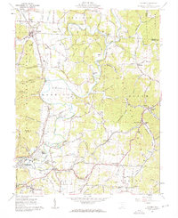
1961 Map of Minford
USGS Topo · Published 1962About this map
The Little Scioto River and its meandering tributaries carve a complex landscape of ridges and hollows in this Scioto County region. Minford serves as a central hub, surrounded by smaller, distinct settlements like Mule Town and Harrison Mills. The era’s industrial footprint is visible through the Scioto Furnace and Wheelers Mill, alongside the essential transit provided by the Chesapeake and Ohio and Baltimore and Ohio railroads.
Find a feature on this map
142 named features on this map. Tap any name to fly to it.
Don’t see what you’re looking for? This feature index may not catch every label — zoom into the map to look around manually.
Map Details
Editions of this 1961 Minford Map
2 editions found
Other maps of this area

1898 · Ironton
USGS Topo · 1:62,500

1900 · Ironton
USGS Topo · 1:62,500

1911 · Sciotoville
USGS Topo · 1:62,500

1912 · Oak Hill
USGS Topo · 1:62,500

1913 · Sciotoville
USGS Topo · 1:62,500

1926 · Greenup
USGS Topo · 1:48,000

1930 · Greenup
USGS Topo · 1:62,500
1953 · Portsmouth
USGS Topo · 1:24,000

1957 · Huntington
USGS Topo · 1:250,000

1960 · Huntington
USGS Topo · 1:250,000