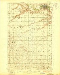
1928 Map of Minot
USGS Topo · Published 1928About this map
The Souris River meanders through the heart of the northern plains in this 1920s survey, anchoring the growing city of Minot. The urban landscape is defined by the heavy presence of the Minneapolis St Paul and Sault Ste Marie and Great Northern railroads, which converge near the Fair Grounds. Beyond the city limits, the terrain transitions into a grid of rural townships including Harrison and Burlington, where the prairie is etched by drainage features like First Larson Coulee and Second Larson Coulee. The map provides a remarkable view of the region's educational and social network before mid-century consolidation, marking numerous rural schoolhouses such as School No 1 and School No 2 scattered across the township sections. Small rail stops and local hubs like Ralston, Drady, and Stringtown appear alongside natural landmarks like Twin Buttes and Rice Lake.
Find a feature on this map
34 named features on this map. Tap any name to fly to it.
Don’t see what you’re looking for? This feature index may not catch every label — zoom into the map to look around manually.
Map Details
Editions of this 1928 Minot Map
Other maps of this area

1928 · Minot
USGS Topo · 1:62,500

1929 · Sawyer
USGS Topo · 1:62,500

1929 · Benedict
USGS Topo · 1:62,500

1948 · Burlington
USGS Topo · 1:24,000

1948 · Burlington
USGS Topo · 1:62,500

1948 · Minot NW
USGS Topo · 1:24,000

1948 · Surrey
USGS Topo · 1:24,000

1949 · Minot NW
USGS Topo · 1:24,000

1949 · Deering SW
USGS Topo · 1:24,000

1949 · Burlington SE
USGS Topo · 1:24,000