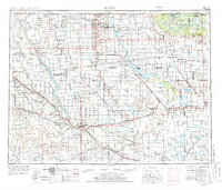
1954 Map of Minot
USGS Topo · Published 1986About this map
The Souris River meanders through this North Dakota landscape, anchoring a region of prairie agriculture and strategic infrastructure during the Cold War. The city of Minot serves as the central hub, supported by the sprawling Minot AFB to its north and a network of Burlington Northern and Soo Line railroad tracks. These lines connect smaller rail-side settlements such as Genoa Siding, Sherwood, and Westhope, reflecting the mid-century grain-shipping economy.
Find a feature on this map
136 named features on this map. Tap any name to fly to it.
Don’t see what you’re looking for? This feature index may not catch every label — zoom into the map to look around manually.
Map Details
Editions of this 1954 Minot Map
3 editions found

Other maps of this area

1928 · Minot
USGS Topo · 1:62,500

1929 · Sawyer
USGS Topo · 1:62,500

1929 · Benedict
USGS Topo · 1:62,500

1929 · Kongsberg
USGS Topo · 1:62,500

1929 · Balfour
USGS Topo · 1:62,500

1930 · Drake
USGS Topo · 1:62,500

1935 · Dunseith
USGS Topo · 1:48,000

1936 · Lake Upsilon
USGS Topo · 1:48,000

1939 · Dunseith
USGS Topo · 1:62,500

1940 · Aylmer
USGS Topo · 1:62,500