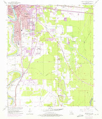
1957 Map of Monroe South
USGS Topo · Published 1975About this map
The Ouachita River serves as the central artery for this mid-century look at the Twin Cities, where the industrial and municipal growth of Monroe and West Monroe is recorded during a period of urban expansion. Purple photorevisions from 1969 and 1975 highlight the outward push of neighborhoods and schools, such as Terzia High Sch and Swayze Sch, into the surrounding lowlands. Beyond the city limits, the landscape is defined by a dense network of bayous including Youngs Bayou and Bayou Mouchoir. These waterways dictated the placement of early settlements and small communities like De Loach and Rilla. Institutional sites like the Louisiana Training Institute and the Conway Hospital are documented alongside older landmarks like Gibson Chapel and the New City Cemetery, providing a detailed record of the region's social and physical infrastructure before late-20th-century development.
Find a feature on this map
38 named features on this map. Tap any name to fly to it.
Don’t see what you’re looking for? This feature index may not catch every label — zoom into the map to look around manually.
Map Details
Editions of this 1957 Monroe South Map
5 editions found

Other maps of this area

1935 · Collinston
USGS Topo · 1:62,500

1935 · Alto
USGS Topo · 1:62,500

1935 · Drew
USGS Topo · 1:62,500

1940 · Monroe
USGS Topo · 1:62,500

1955 · Jackson
USGS Topo · 1:250,000

1955 · Shreveport
USGS Topo · 1:250,000

1956 · Shreveport
USGS Topo · 1:250,000

1957 · Monroe North
USGS Topo · 1:62,500

1957 · West Monroe North
USGS Topo · 1:24,000

1957 · Mangham
USGS Topo · 1:62,500