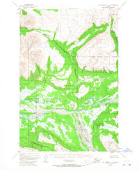
1951 Map of Mount Katmai C-3
USGS Topo · Published 1968About this map
The confluence of the Savonoski River and Rainbow River anchor this topographic survey, which documents a remote wilderness area within the Katmai National Monument. Based on 1951 aerial photography, the map illustrates the complex drainage patterns of glacial and volcanic landscapes before modern development. Notable water features like Hardscrabble Creek and Gorge Creek carve through the high-elevation terrain, which is defined by significant vertical relief and expansive wetlands. The presence of the Kenai Peninsula Bor boundary in the northeast corner highlights the administrative divisions of this sparsely populated region. This edition, featuring minor revisions from the mid-1960s, serves as a vital record of the monument's geography during the mid-20th century, prior to the expansion of contemporary park infrastructure.
Find a feature on this map
8 named features on this map. Tap any name to fly to it.
Don’t see what you’re looking for? This feature index may not catch every label — zoom into the map to look around manually.
Map Details
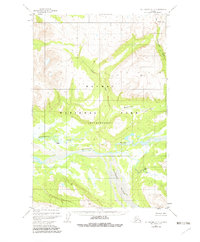
Editions of this 1951 Mount Katmai C-3 Map
3 editions found
Other maps of this area

1948 · Mt Katmai
USGS Topo · 1:250,000

1951 · Mt Katmai
USGS Topo · 1:250,000

1951 · Mount Katmai C-3
USGS Topo · 1:63,360

1951 · Mount Katmai B-4
USGS Topo · 1:63,360

1951 · Mount Katmai C-4
USGS Topo · 1:63,360

1951 · Mount Katmai C-2
USGS Topo · 1:63,360

1951 · Mount Katmai D-4
USGS Topo · 1:63,360

1951 · Mount Katmai D-2
USGS Topo · 1:63,360

1951 · Mount Katmai D-3
USGS Topo · 1:63,360

1951 · Mount Katmai B-3
USGS Topo · 1:63,360