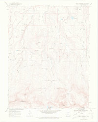
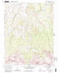
1967 Map of Mount Sneffels
USGS Topo · Published 1971About this map
Mount Sneffels towers over a high-altitude landscape of the Uncompahgre National Forest defined by steep basins and the headwaters of Dallas Creek. This mid-century survey documents a transition from the heavy mining of earlier decades to a terrain marked by ranching outposts and high-country trails. Evidence of the region’s industrial history is found in the Blaine Mine and an Old RR Grade tucked into the western slopes, while smaller outposts like Vance Place and Kelly Camp denote the seasonal human presence in these alpine reaches. The topography is intricately detailed, showing the drainage systems of Stough Draw and Blaine Draw alongside established landmarks such as Miller Mesa and Mears Peak. For the researcher, the map captures the late 1960s state of these peaks before modern wilderness designations shifted the use of the land.
Find a feature on this map
50 named features on this map. Tap any name to fly to it.
Don’t see what you’re looking for? This feature index may not catch every label — zoom into the map to look around manually.
Map Details
Editions of this 1967 Mount Sneffels Map
5 editions found
Other maps of this area

1897 · Telluride
USGS Topo · 1:62,500

1897 · Silverton
USGS Topo · 1:62,500

1901 · Silverton
USGS Topo · 1:62,500

1902 · Silverton
USGS Topo · 1:62,500

1902 · Ouray
USGS Topo · 1:62,500

1904 · Ouray
USGS Topo · 1:62,500

1904 · Telluride
USGS Topo · 1:62,500

1909 · Montrose
USGS Topo · 1:125,000

1911 · Montrose
USGS Topo · 1:125,000

1945 · Durango
USGS Topo · 1:250,000